
Carte topographique Bel Aire
Carte interactive
Cliquez sur la carte pour afficher l’altitude.
À propos de cette carte
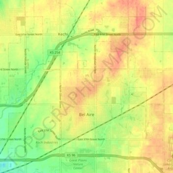
Nom : Carte topographique Bel Aire, altitude, relief.
Lieu : Bel Aire, Sedgwick County, Kansas, United States (37.75229 -97.28077 37.79596 -97.18976)
Altitude moyenne : 424 m
Altitude minimum : 396 m
Altitude maximum : 444 m
Bel Aire is located at 37°45′50″N 97°15′58″W / 37.76389°N 97.26611°W / 37.76389; -97.26611 (37.763758, −97.266177) at an elevation of 1,394 feet (425 m). It lies on the north side of the East Fork of Chisholm Creek roughly 6 mi (9.7 km) northeast of the Arkansas River in the Wellington-McPherson Lowlands region of the Great Plains. Located on the south side of K-254 in south-central Kansas, Bel Aire is within the Wichita metropolitan area, bordered by Wichita to the south and west and bordered by Kechi to the north.
Autres cartes topographiques
Cliquez sur une carte pour visualiser sa topographie, son altitude et son relief.
Wichita
United States > Kansas > Sedgwick County
Wichita, Sedgwick County, Kansas, United States
Altitude moyenne : 408 m
Colwich
United States > Kansas > Sedgwick County
Colwich, Sedgwick County, Kansas, United States
Altitude moyenne : 421 m
Mulvane
United States > Kansas > Sedgwick County
Mulvane, Sedgwick County, Kansas, 67110, United States
Altitude moyenne : 386 m
Wichita
United States > Kansas > Sedgwick County > Wichita
Wichita, Sedgwick County, Kansas, 67202, United States
Altitude moyenne : 410 m
Andale
United States > Kansas > Sedgwick County
Andale, Sedgwick County, Kansas, United States
Altitude moyenne : 440 m
Kechi
United States > Kansas > Sedgwick County
Kechi, Sedgwick County, Kansas, United States
Altitude moyenne : 429 m
Garden Plain
United States > Kansas > Sedgwick County
Garden Plain, Sedgwick County, Kansas, United States
Altitude moyenne : 444 m
Maize
United States > Kansas > Sedgwick County
Maize, Sedgwick County, Kansas, United States
Altitude moyenne : 414 m
Valley Center
United States > Kansas > Sedgwick County
Valley Center, Sedgwick County, Kansas, United States
Altitude moyenne : 413 m
Park City
United States > Kansas > Sedgwick County
Park City, Sedgwick County, Kansas, United States
Altitude moyenne : 421 m
Haysville
United States > Kansas > Sedgwick County
Haysville, Riverside Township, Sedgwick County, Kansas, United States
Altitude moyenne : 388 m
Minneha
United States > Kansas > Sedgwick County > Wichita
Minneha, Wichita, Sedgwick County, Kansas, 67206, United States
Altitude moyenne : 423 m
Valley Center
United States > Kansas > Sedgwick County > Valley Center > Valley Center
Valley Center, Sedgwick County, Kansas, United States
Altitude moyenne : 415 m
Derby
United States > Kansas > Sedgwick County
Derby, Sedgwick County, Kansas, 67037, United States
Altitude moyenne : 393 m
Mount Hope
United States > Kansas > Sedgwick County > Mount Hope
Mount Hope, Sedgwick County, Kansas, United States
Altitude moyenne : 439 m