
Carte topographique Carson
Carte interactive
Cliquez sur la carte pour afficher l’altitude.
À propos de cette carte
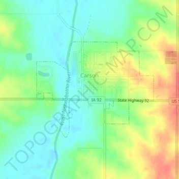
Nom : Carte topographique Carson, altitude, relief.
Lieu : Carson, Pottawattamie County, Iowa, 51525, United States (41.22711 -95.43185 41.24157 -95.40829)
Altitude moyenne : 341 m
Altitude minimum : 319 m
Altitude maximum : 374 m
Autres cartes topographiques
Cliquez sur une carte pour visualiser sa topographie, son altitude et son relief.
Hitchcock Nature Center
United States > Iowa > Pottawattamie County
Hitchcock Nature Center, Pottawattamie County, Iowa, United States
Altitude moyenne : 338 m
Avoca
United States > Iowa > Pottawattamie County > Avoca
Avoca, Pottawattamie County, Iowa, 51521, United States
Altitude moyenne : 353 m
Underwood
United States > Iowa > Pottawattamie County
Underwood, Pottawattamie County, Iowa, United States
Altitude moyenne : 339 m