
Faire un don
Équipez-vous pour votre prochaine aventure :
En tant que Partenaire Amazon, ce site perçoit une commission sur les achats éligibles sans surcoût pour vous.
Carte topographique Huntley
Cliquez sur la carte pour afficher l’altitude.
Faire un don
Équipez-vous pour votre prochaine aventure :
En tant que Partenaire Amazon, ce site perçoit une commission sur les achats éligibles sans surcoût pour vous.
Huntley
During the Yellowstone Flood of 1937, the damage to Huntley was more extensive, percentage-wise, than in any other community in the region. Much of the original town of Huntley was destroyed and significant portions of the land it occupied was claimed or compromised by the Yellowstone River. The flood damage included washing away the suspension bridge that allowed adjacent Highway 312 to cross the river. After the flood, the site of the town was relocated from the north side of the river to the higher elevation on the south bank.
Faire un don
Équipez-vous pour votre prochaine aventure :
En tant que Partenaire Amazon, ce site perçoit une commission sur les achats éligibles sans surcoût pour vous.
À propos de cette carte
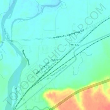
Nom : Carte topographique Huntley, altitude, relief.
Lieu : Huntley, Yellowstone County, Montana, United States (45.88711 -108.31916 45.91403 -108.29097)
Altitude moyenne : 924 m
Altitude minimum : 911 m
Altitude maximum : 965 m
Faire un don
Équipez-vous pour votre prochaine aventure :
En tant que Partenaire Amazon, ce site perçoit une commission sur les achats éligibles sans surcoût pour vous.