

Carte topographique Goshen
Cliquez sur la carte pour afficher l’altitude.
Goshen
Settlements in the town include Goshen, near the town's western border, and Goshen Four Corners, in the center of the southern part of town. Vermont Route 73 runs east–west through Goshen, passing through Goshen Four Corners, and crossing the crest of the Green Mountains at Brandon Gap (elevation 2,183 ft or 665 m) near the town's east border. The Long Trail crosses Route 73 at Brandon Gap and passes over the summits of Mount Horrid (3,216 ft or 980 m) and Cape Lookoff Mountain (3,350 ft or 1,020 m) within Goshen. Goshen Mountain (3,292 ft or 1,003 m) is in the southeast corner of the town. Most of Goshen lies within the Green Mountain National Forest.
À propos de cette carte
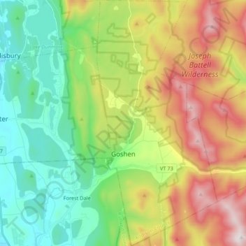
Nom : Carte topographique Goshen, altitude, relief.
Lieu : Goshen, Addison County, Vermont, United States (43.80486 -73.04002 43.92284 -72.95974)
Altitude moyenne : 463 m
Altitude minimum : 111 m
Altitude maximum : 1’063 m
Autres cartes topographiques
Cliquez sur une carte pour visualiser sa topographie, son altitude et son relief.

Kingsland Bay
United States > Vermont > Addison County > Ferrisburgh > Ecole Champlain
Altitude moyenne : 32 m


Abbey Pond Cascades (lower)
United States > Vermont > Addison County > Middlebury
Altitude moyenne : 305 m

Lake Dunmore
United States > Vermont > Addison County > Salisbury > Lake Dunmore
Altitude moyenne : 192 m


