
Carte topographique Thanikkudam
Cliquez sur la carte pour afficher l’altitude.
À propos de cette carte
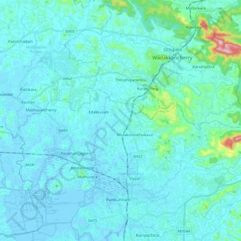
Nom : Carte topographique Thanikkudam, altitude, relief.
Altitude moyenne : 36 m
Altitude minimum : -7 m
Altitude maximum : 406 m
Autres cartes topographiques
Cliquez sur une carte pour visualiser sa topographie, son altitude et son relief.
Thrissur
Thrissur is the headquarters of Thrissur district, in the centre of the Indian state of Kerala. The city is 75 km north-east of Kochi, 133 km south-west of Coimbatore, 124 km south-east of Kozhikode and 151 km north of Changanacherry. The city is located in a hillock called Thekkinkadu Maidan which is the…
Altitude moyenne : 36 m
Kulam -Balakrishnan,Karamangattil, Chazhoor, Chetakulam
India > Kerala > Thrissur > Puthenpeedika
Altitude moyenne : 6 m
Thrissur
Thrissur is the headquarters of Thrissur district, in the center of the Indian state of Kerala. The city is 75 km north-east of Kochi, 133 km south-west of Coimbatore, 124 km south-east of Kozhikode and 151 km north of Changanacherry. The city is located in a hillock called Thekkinkadu Maidan which is the…
Altitude moyenne : 36 m
Thrissur
Thrissur is the headquarters of Thrissur district, in the centre of the Indian state of Kerala. The city is 75 km north-east of Kochi, 133 km south-west of Coimbatore, 124 km south-east of Kozhikode and 151 km north of Changanacherry. The city is located in a hillock called Thekkinkadu Maidan which is the…
Altitude moyenne : 36 m