
Carte topographique North Frankfort
Carte interactive
Cliquez sur la carte pour afficher l’altitude.
À propos de cette carte
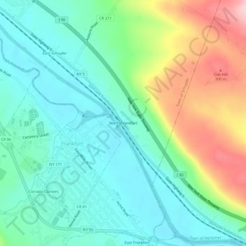
Nom : Carte topographique North Frankfort, altitude, relief.
Altitude moyenne : 177 m
Altitude minimum : 108 m
Altitude maximum : 337 m
Autres cartes topographiques
Cliquez sur une carte pour visualiser sa topographie, son altitude et son relief.
West Schuyler
United States > New York > Herkimer County > Town of Schuyler
West Schuyler, Town of Schuyler, Herkimer County, New York, 13504, United States
Altitude moyenne : 144 m
Johnson Corners
United States > New York > Herkimer County > Town of Schuyler
Johnson Corners, Town of Schuyler, Herkimer County, New York, United States
Altitude moyenne : 230 m
Baker Corners
United States > New York > Herkimer County > Town of Schuyler
Baker Corners, Town of Schuyler, Herkimer County, New York, 13504, United States
Altitude moyenne : 181 m
East Schuyler
United States > New York > Herkimer County > Town of Schuyler
East Schuyler, Town of Schuyler, Herkimer County, New York, 13340, United States
Altitude moyenne : 159 m