
Carte topographique Manning
Carte interactive
Cliquez sur la carte pour afficher l’altitude.
À propos de cette carte
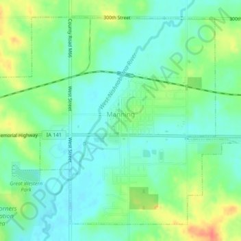
Nom : Carte topographique Manning, altitude, relief.
Lieu : Manning, Carroll County, Iowa, United States (41.89571 -95.08538 41.92112 -95.04568)
Altitude moyenne : 415 m
Altitude minimum : 398 m
Altitude maximum : 448 m
Autres cartes topographiques
Cliquez sur une carte pour visualiser sa topographie, son altitude et son relief.
Willey
United States > Iowa > Carroll County
Willey, Carroll County, Iowa, United States
Altitude moyenne : 390 m
Templeton
United States > Iowa > Carroll County
Templeton, Carroll County, Iowa, United States
Altitude moyenne : 434 m
Middle Raccoon River
United States > Iowa > Carroll County > Carroll
Middle Raccoon River, Rolling Hills, Carroll, Carroll County, Iowa, 51401, United States
Altitude moyenne : 385 m
Ralston
United States > Iowa > Carroll County > Ralston
Ralston, Carroll County, Iowa, 51459, United States
Altitude moyenne : 342 m
Dedham
United States > Iowa > Carroll County
Dedham, Carroll County, Iowa, United States
Altitude moyenne : 395 m