
Carte topographique Municipio de Esquel
Carte interactive
Cliquez sur la carte pour afficher l’altitude.
À propos de cette carte
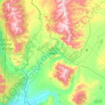
Nom : Carte topographique Municipio de Esquel, altitude, relief.
Altitude moyenne : 965 m
Altitude minimum : 345 m
Altitude maximum : 2’175 m
Owing to its location on the immediate leeward side of the Andes, Esquel has a cool summer Mediterranean climate (Köppen Csb) bordering on a Humid continental climate (Köppen Dsb). Other climate systems, such as the Trewartha climate classification, place it within the oceanic zone (Do), like much of Western Europe and the Pacific Northwest. Temperatures are relatively cold for its climate due to its higher altitude. Summers are mild with warm temperatures during the afternoon followed by cool nights. The mean temperature during the summer is around 14 °C (57.2 °F). It's the sunniest season, averaging as much as 10 hours of sunshine per day in January with an average of 7–8 clear days and only 5-7 overcast days. Spring and fall are transition seasons featuring mild temperatures during the day and cool to cold nights. Spring starts out with cool temperatures during the day and very cold nights which progressively becomes warmer. Both spring and fall have highly variable weather.
Autres cartes topographiques
Cliquez sur une carte pour visualiser sa topographie, son altitude et son relief.
Plaza Dino Olivares
Argentina > Chubut Province > Comodoro Rivadavia
Plaza Dino Olivares, 25 de Mayo, Comodoro Rivadavia, Departamento Escalante, Chubut Province, 9000, Argentina
Altitude moyenne : 28 m
Comuna Rural de Aldea Beleiro
Comuna Rural de Aldea Beleiro, Departamento Río Senguer, Chubut Province, 9037, Argentina
Altitude moyenne : 731 m
Valdes Peninsula
Valdes Peninsula, Chubut Province, Argentina
Altitude moyenne : 28 m
Tecka River
Tecka River, Departamento Futaleufú, Chubut Province, Argentina
Altitude moyenne : 901 m
Leleque
Argentina > Chubut Province > Leleque
Leleque, Departamento Cushamen, Chubut Province, Argentina
Altitude moyenne : 668 m
Municipio de Puerto Madryn
Municipio de Puerto Madryn, Departamento Biedma, Chubut Province, Argentina
Altitude moyenne : 76 m