
Carte topographique Puketutu Island
Carte interactive
Cliquez sur la carte pour afficher l’altitude.
À propos de cette carte
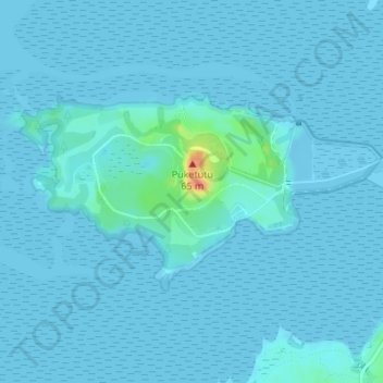
Nom : Carte topographique Puketutu Island, altitude, relief.
Lieu : Puketutu Island, Māngere-Ōtāhuhu, Auckland, New Zealand (-36.97400 174.73244 -36.95997 174.76440)
Altitude moyenne : 3 m
Altitude minimum : -2 m
Altitude maximum : 54 m
Autres cartes topographiques
Cliquez sur une carte pour visualiser sa topographie, son altitude et son relief.
Crater Hill
New Zealand > Auckland > Mangere-Otahuhu
Crater Hill, Māngere-Ōtāhuhu, Auckland, 2024, New Zealand
Altitude moyenne : 17 m
Ngarango Otainui Island
New Zealand > Auckland > Mangere-Otahuhu
Ngarango Otainui Island, Mangere-Otahuhu, Auckland, New Zealand
Altitude moyenne : 6 m
Mangere Inlet
New Zealand > Auckland > Mangere-Otahuhu
Mangere Inlet, Norana Avenue, Favona, Mangere-Otahuhu, Auckland, 2024, New Zealand
Altitude moyenne : 7 m