
Carte topographique Moulès
Carte interactive
Cliquez sur la carte pour afficher l’altitude.
À propos de cette carte
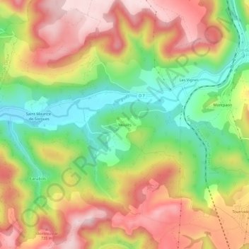
Nom : Carte topographique Moulès, altitude, relief.
Altitude moyenne : 597 m
Altitude minimum : 436 m
Altitude maximum : 754 m
Autres cartes topographiques
Cliquez sur une carte pour visualiser sa topographie, son altitude et son relief.
Pas Farrat
France > Occitanie > Aveyron > Fondamente
Pas Farrat, Fondamente, Millau, Aveyron, Occitanie, France métropolitaine, 12540, France
Altitude moyenne : 710 m
Saint-Maurice-de-Sorgues
France > Occitanie > Aveyron > Fondamente
Saint-Maurice-de-Sorgues, Fondamente, Millau, Aveyron, Occitanie, France métropolitaine, 12540, France
Altitude moyenne : 582 m
Les Cluges
France > Occitanie > Aveyron > Fondamente
Les Cluges, Fondamente, Millau, Aveyron, Occitanie, France métropolitaine, 12540, France
Altitude moyenne : 621 m
Pas Farrat
France > Occitanie > Aveyron > Fondamente
Pas Farrat, Fondamente, Millau, Aveyron, Occitanie, France métropolitaine, 12540, France
Altitude moyenne : 710 m