
Carte topographique Neukölln
Carte interactive
Cliquez sur la carte pour afficher l’altitude.
À propos de cette carte
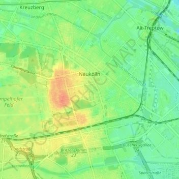
Nom : Carte topographique Neukölln, altitude, relief.
Lieu : Neukölln, Berlin, Germany (52.45876 13.40608 52.49587 13.47855)
Altitude moyenne : 43 m
Altitude minimum : 26 m
Altitude maximum : 67 m
Neukölln lies on the geological border between the shallow Berliner Urstromtal glacial valley and the Tempelhofer Berge, which are situated in the northernmost region of the Teltow ground moraine plateau, rising to the south of Hermannplatz, in what is mostly the typical low-lying marshy woodlands with a mainly flat topography of the North European Plain.
Autres cartes topographiques
Cliquez sur une carte pour visualiser sa topographie, son altitude et son relief.
Friedrichshain-Kreuzberg
Friedrichshain-Kreuzberg, Berlin, Germany
Altitude moyenne : 45 m
Charlottenburg-Wilmersdorf
Charlottenburg-Wilmersdorf, Berlin, Germany
Altitude moyenne : 44 m
Volkspark Friedrichshain
Volkspark Friedrichshain, Barnimkiez, Friedrichshain, Friedrichshain-Kreuzberg, Berlin, 10249, Germany
Altitude moyenne : 49 m
Charlottenburg
Charlottenburg, Charlottenburg-Wilmersdorf, Berlin, Germany
Altitude moyenne : 41 m
Biesenhorster Sand
Biesenhorster Sand, Tangentiale Verbindung Ost, , Biesdorf, Marzahn-Hellersdorf, Berlin, 12683, Germany
Altitude moyenne : 38 m
Volkspark am Weinberg
Volkspark am Weinberg, Spandauer Vorstadt, Mitte, Berlin, 10119, Germany
Altitude moyenne : 47 m