
Carte topographique Kunigal
Carte interactive
Cliquez sur la carte pour afficher l’altitude.
À propos de cette carte
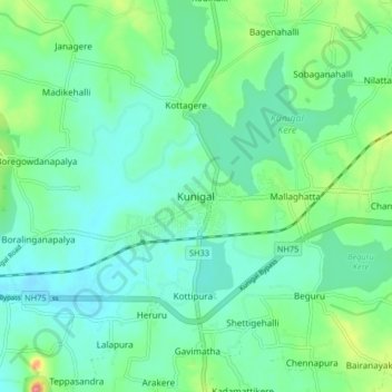
Nom : Carte topographique Kunigal, altitude, relief.
Altitude moyenne : 775 m
Altitude minimum : 751 m
Altitude maximum : 850 m
Kunigal is located at 13°01′N 77°02′E / 13.02°N 77.03°E / 13.02; 77.03. It has an average elevation of 773 metres (2536 feet). It is situated on the National Highway 48 ( NH-48 ) connecting Bangalore and Mangalore and State Highway 33 connecting Tumakuru and Madduru. Recently opened Hassan-Bangalore railway line transverses through Kunigal.
Autres cartes topographiques
Cliquez sur une carte pour visualiser sa topographie, son altitude et son relief.
Sugganahalli
India > Karnataka > Kunigal taluk
Sugganahalli, Kunigal taluk, Tumakuru District, Karnataka, India
Altitude moyenne : 676 m
Ujjani
India > Karnataka > Kunigal taluk
Ujjani, Kunigal taluk, Tumkur district, Karnataka, 572123, India
Altitude moyenne : 717 m