
Faire un don
Équipez-vous pour votre prochaine aventure :
En tant que Partenaire Amazon, ce site perçoit une commission sur les achats éligibles sans surcoût pour vous.
Carte topographique Rauhenebrach
Cliquez sur la carte pour afficher l’altitude.
Faire un don
Équipez-vous pour votre prochaine aventure :
En tant que Partenaire Amazon, ce site perçoit une commission sur les achats éligibles sans surcoût pour vous.
Rauhenebrach
mit einem BHU (Brusthöhenumfang) von 7,20 m. ⊙49.87613110.593019
Faire un don
Équipez-vous pour votre prochaine aventure :
En tant que Partenaire Amazon, ce site perçoit une commission sur les achats éligibles sans surcoût pour vous.
À propos de cette carte
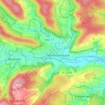
Nom : Carte topographique Rauhenebrach, altitude, relief.
Lieu : Rauhenebrach, Landkreis Haßberge, Bayern, 96181, Deutschland (49.86965 10.52932 49.90965 10.56932)
Altitude moyenne : 360 m
Altitude minimum : 296 m
Altitude maximum : 439 m
Faire un don
Équipez-vous pour votre prochaine aventure :
En tant que Partenaire Amazon, ce site perçoit une commission sur les achats éligibles sans surcoût pour vous.