
Carte topographique Shurabak
Carte interactive
Cliquez sur la carte pour afficher l’altitude.
À propos de cette carte
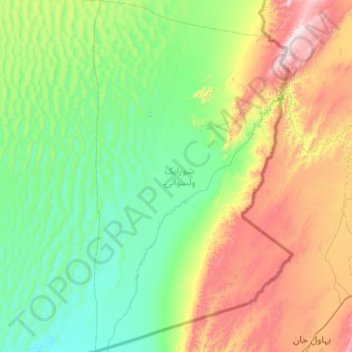
Nom : Carte topographique Shurabak, altitude, relief.
Lieu : Shurabak, Kandahar Province, Afghanistan (29.72940 65.80473 30.59888 66.37347)
Altitude moyenne : 1’243 m
Altitude minimum : 912 m
Altitude maximum : 2’258 m
Shorabak District (also Shorawak ) is a remote district situated in the southeastern part of Kandahar Province, Afghanistan, 110 km south and east of Kandahar. It borders Reg District to the west, Spin Boldak District to the north and Pakistan to the east and south. The population is 10,200 (2006). The district center Shorabak is located on 30°11′00″N 66°06′00″E / 30.1833°N 66.1000°E / 30.1833; 66.1000 at 985 m altitude in the Eastern part of the district.
Autres cartes topographiques
Cliquez sur une carte pour visualiser sa topographie, son altitude et son relief.
Sangesar
Afghanistan > Kandahar Province > Zhari
Sangesar, Zhari, Kandahar Province, Afghanistan
Altitude moyenne : 943 m
Kandahar
Afghanistan > Kandahar Province > Kandahar
Kandahar, Kandahar Province, 3801, Afghanistan
Altitude moyenne : 1’048 m