
Carte topographique Lichtenfels
Carte interactive
Cliquez sur la carte pour afficher l’altitude.
À propos de cette carte
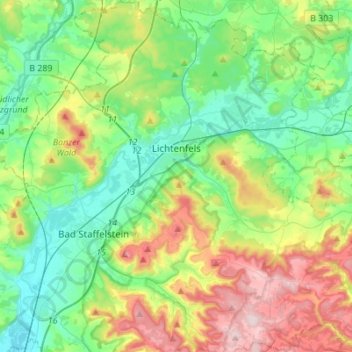
Nom : Carte topographique Lichtenfels, altitude, relief.
Lieu : Lichtenfels, Landkreis Lichtenfels, Bayern, 96215, Deutschland (50.04347 10.97516 50.21959 11.18991)
Altitude moyenne : 348 m
Altitude minimum : 243 m
Altitude maximum : 575 m
Bohnberg | Buch am Forst | Burgberg | Degendorf | Eichig | Friesenhof | Gnellenroth | Hammer | Heinach | Isling | Karolinenhöhe | Klosterlangheim | Kösten | Köttel | Krappenroth | Lahm | Mistelfeld | Mönchkröttendorf | Nassanger | Oberlangheim | Oberwallenstadt | Reundorf | Roth | Rothmannsthal | Schney | Schönsreuth | Seehof | Seubelsdorf | Stetten | Stöcken | Tiefenroth | Trieb | Unterwallenstadt | Weingarten
Autres cartes topographiques
Cliquez sur une carte pour visualiser sa topographie, son altitude et son relief.
Schwabthal
Deutschland > Bayern > Landkreis Lichtenfels > Bad Staffelstein
Schwabthal, Bad Staffelstein, Landkreis Lichtenfels, Bayern, Deutschland
Altitude moyenne : 432 m
Döringstadt
Deutschland > Bayern > Landkreis Lichtenfels
Döringstadt, Ebensfeld, Landkreis Lichtenfels, Bayern, 96250, Deutschland
Altitude moyenne : 299 m
Schwürbitz
Deutschland > Bayern > Landkreis Lichtenfels
Schwürbitz, Michelau i.OFr., Landkreis Lichtenfels, Bayern, 96275, Deutschland
Altitude moyenne : 292 m