
Carte topographique Roanoke
Carte interactive
Cliquez sur la carte pour afficher l’altitude.
À propos de cette carte
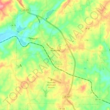
Nom : Carte topographique Roanoke, altitude, relief.
Lieu : Roanoke, Randolph County, Alabama, 36274, United States (33.10860 -85.41184 33.18588 -85.33033)
Altitude moyenne : 252 m
Altitude minimum : 209 m
Altitude maximum : 304 m
Autres cartes topographiques
Cliquez sur une carte pour visualiser sa topographie, son altitude et son relief.
Wedowee Club Lake Dam
United States > Alabama > Randolph County
Wedowee Club Lake Dam, Randolph County, Alabama, United States
Altitude moyenne : 280 m
Wedowee
United States > Alabama > Randolph County
Wedowee, Randolph County, Alabama, United States
Altitude moyenne : 278 m
High Pine
United States > Alabama > Randolph County
High Pine, Randolph County, Alabama, United States
Altitude moyenne : 235 m
Flat Rock
United States > Alabama > Randolph County
Flat Rock, Randolph County, Alabama, United States
Altitude moyenne : 253 m
Melody Lane
United States > Alabama > Randolph County > Roanoke
Melody Lane, Roanoke, Randolph County, Alabama, 36274, United States
Altitude moyenne : 262 m
Woodland
United States > Alabama > Randolph County
Woodland, Randolph County, Alabama, 36280, United States
Altitude moyenne : 313 m
Newell
United States > Alabama > Randolph County > Newell
Newell, Randolph County, Alabama, 36270, United States
Altitude moyenne : 286 m
Wadley
United States > Alabama > Randolph County
Wadley, Randolph County, Alabama, United States
Altitude moyenne : 209 m
Roanoke
United States > Alabama > Randolph County > Roanoke
Roanoke, Randolph County, Alabama, 36274, United States
Altitude moyenne : 251 m