
Carte topographique Saluda
Carte interactive
Cliquez sur la carte pour afficher l’altitude.
À propos de cette carte
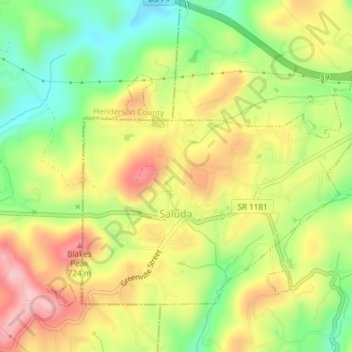
Nom : Carte topographique Saluda, altitude, relief.
Lieu : Saluda, Polk County, North Carolina, 28773, United States (35.22812 -82.36302 35.25086 -82.32559)
Altitude moyenne : 635 m
Altitude minimum : 498 m
Altitude maximum : 735 m
Saluda is located in southwestern Polk County at 35°14′16″N 82°20′49″W / 35.237856°N 82.346870°W / 35.237856; -82.346870 (35.237856, -82.346870). Two small parts of the city extend west and north into Henderson County. The elevation on Main Street is 2,097 feet (639 m) above sea level, while the elevation at the bottom end of the Saluda Grade, in Tryon, is 1,080 feet (329.1 m).
Autres cartes topographiques
Cliquez sur une carte pour visualiser sa topographie, son altitude et son relief.
Hickory Grove
United States > North Carolina > Polk County
Hickory Grove, Polk County, North Carolina, United States
Altitude moyenne : 281 m
Mill Spring
United States > North Carolina > Polk County
Mill Spring, Polk County, North Carolina, 28756, United States
Altitude moyenne : 318 m
Green River
United States > North Carolina > Polk County
Green River, Polk County, North Carolina, 28756, United States
Altitude moyenne : 538 m
Lake Adger
United States > North Carolina > Polk County
Lake Adger, Polk County, North Carolina, United States
Altitude moyenne : 312 m
Tryon
United States > North Carolina > Polk County
Tryon, Polk County, North Carolina, United States
Altitude moyenne : 333 m
Melrose
United States > North Carolina > Polk County > Melrose
Melrose, Polk County, North Carolina, 28773, United States
Altitude moyenne : 610 m
Green Creek
United States > North Carolina > Polk County > Green Creek
Green Creek, Polk County, North Carolina, United States
Altitude moyenne : 290 m