
Carte topographique Plantagenet
Carte interactive
Cliquez sur la carte pour afficher l’altitude.
À propos de cette carte
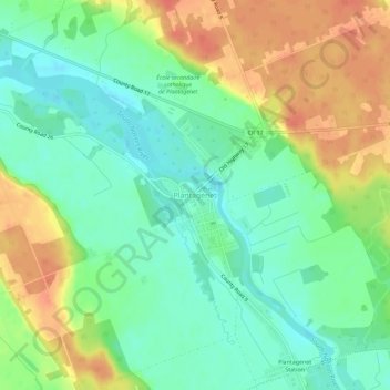
Nom : Carte topographique Plantagenet, altitude, relief.
Altitude moyenne : 61 m
Altitude minimum : 40 m
Altitude maximum : 90 m
Autres cartes topographiques
Cliquez sur une carte pour visualiser sa topographie, son altitude et son relief.
Lefaivre
Canada > Ontario > Prescott and Russell Counties > Alfred and Plantagenet
Lefaivre, Alfred and Plantagenet, Prescott and Russell Counties, Eastern Ontario, Ontario, K0B 1J0, Canada
Altitude moyenne : 50 m
Wendover
Canada > Ontario > Prescott and Russell Counties > Alfred and Plantagenet > Wendover
Wendover, Alfred and Plantagenet, Prescott and Russell Counties, Eastern Ontario, Ontario, K0A 3K0, Canada
Altitude moyenne : 49 m
Alfred
Canada > Ontario > Prescott and Russell Counties > Alfred and Plantagenet
Alfred, Alfred and Plantagenet, Prescott and Russell Counties, Eastern Ontario, Ontario, K0B 1A0, Canada
Altitude moyenne : 64 m