
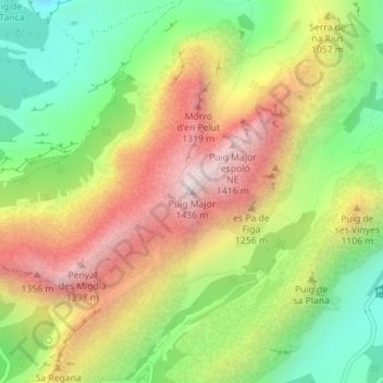
Carte topographique Puig Major
Carte interactive
Cliquez sur la carte pour afficher l’altitude.
À propos de cette carte
Nom : Carte topographique Puig Major, altitude, relief.
Altitude moyenne : 949 m
Altitude minimum : 510 m
Altitude maximum : 1’444 m
Puig Major is the highest peak on the Spanish island of Majorca. With an elevation of 1,436 m (4,711 ft) above sea level. It is situated in the Serra de Tramuntana mountains. As the mountain is located in a military zone, the neighbouring peak Puig de Massanella (1,364 m) is considered the highest accessible summit on the island.
Autres cartes topographiques
Cliquez sur une carte pour visualiser sa topographie, son altitude et son relief.
Lluc
Spain > Balearic Islands > Serra de Tramuntana > Escorca
Lluc, Escorca, Serra de Tramuntana, Balearic Islands, 07315, Spain
Altitude moyenne : 603 m