
Carte topographique Templeton
Carte interactive
Cliquez sur la carte pour afficher l’altitude.
À propos de cette carte
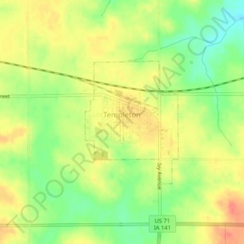
Nom : Carte topographique Templeton, altitude, relief.
Lieu : Templeton, Carroll County, Iowa, United States (41.91087 -94.94853 41.92445 -94.93466)
Altitude moyenne : 434 m
Altitude minimum : 407 m
Altitude maximum : 455 m
Autres cartes topographiques
Cliquez sur une carte pour visualiser sa topographie, son altitude et son relief.
Ralston
United States > Iowa > Carroll County
Ralston, Carroll County, Iowa, 51459, United States
Altitude moyenne : 342 m
Coon Rapids
United States > Iowa > Carroll County
Coon Rapids, Carroll County, Iowa, United States
Altitude moyenne : 363 m
Dedham
United States > Iowa > Carroll County
Dedham, Carroll County, Iowa, United States
Altitude moyenne : 395 m
Manning
United States > Iowa > Carroll County
Manning, Carroll County, Iowa, United States
Altitude moyenne : 415 m
Glidden
United States > Iowa > Carroll County
Glidden, Carroll County, Iowa, United States
Altitude moyenne : 373 m