
Carte topographique Mount Greylock
Carte interactive
Cliquez sur la carte pour afficher l’altitude.
À propos de cette carte
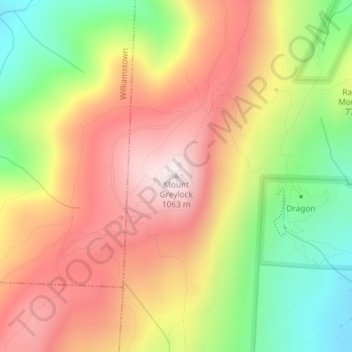
Nom : Carte topographique Mount Greylock, altitude, relief.
Altitude moyenne : 746 m
Altitude minimum : 386 m
Altitude maximum : 1’062 m
Geographically, Mount Greylock is part of an 11-mile-long (18 km) by 4+1⁄2-mile-wide (7 km) island-like range that runs north-south between the Hoosac Range to the east, the Green Mountains to the north, the Berkshires to both the south and east, and the Taconic Mountains to the west with which it is geologically associated; all ranges are associated with the Appalachian mountain chain. The summit of Mount Greylock is located in Adams, Massachusetts, but the mountain also extends into Cheshire, Lanesborough, New Ashford, North Adams and Williamstown. The range includes peaks with elevation less than Greylock, such as Saddle Ball Mountain and Mount Fitch.
Autres cartes topographiques
Cliquez sur une carte pour visualiser sa topographie, son altitude et son relief.
Maple Grove
United States > Massachusetts > Berkshire County > Adams
Maple Grove, Adams, Berkshire County, Massachusetts, 01220, United States
Altitude moyenne : 342 m