
Carte topographique Oberwürzbach
Carte interactive
Cliquez sur la carte pour afficher l’altitude.
À propos de cette carte
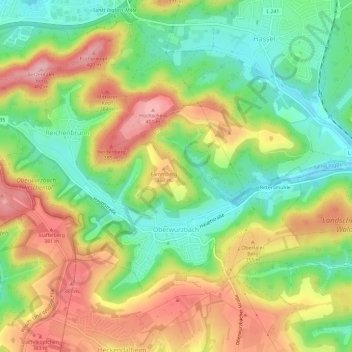
Nom : Carte topographique Oberwürzbach, altitude, relief.
Altitude moyenne : 314 m
Altitude minimum : 237 m
Altitude maximum : 407 m
Autres cartes topographiques
Cliquez sur une carte pour visualiser sa topographie, son altitude et son relief.
Wallburg
Deutschland > Saarland > Saarpfalz-Kreis > St. Ingbert
Wallburg, Hochscheidstraße, Reichenbrunn, Oberwürzbach, St. Ingbert, Saarpfalz-Kreis, Saarland, 66386, Deutschland
Altitude moyenne : 309 m