
Carte topographique دهستان ماربین سفلی
Carte interactive
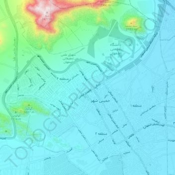
Cliquez sur la carte pour afficher l’altitude.
À propos de cette carte
Nom : Carte topographique دهستان ماربین سفلی, altitude, relief.
Altitude moyenne : 1’692 m
Altitude minimum : 1’580 m
Altitude maximum : 2’469 m
Autres cartes topographiques
Cliquez sur une carte pour visualiser sa topographie, son altitude et son relief.
Khomeyni Shahr
Iran > Isfahan Province > Khomeyni Shahr County
Khomeyni Shahr, بخش مرکزی شهرستان خمینی شهر, Khomeyni Shahr County, Isfahan Province, Iran
Altitude moyenne : 1’654 m