
Carte topographique Wichita
Carte interactive
Cliquez sur la carte pour afficher l’altitude.
À propos de cette carte
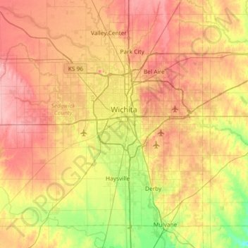
Nom : Carte topographique Wichita, altitude, relief.
Lieu : Wichita, Sedgwick County, Kansas, United States (37.48902 -97.73435 37.84020 -97.15300)
Altitude moyenne : 408 m
Altitude minimum : 355 m
Altitude maximum : 459 m
The city lies on the Arkansas River near the western edge of the Flint Hills in the Wellington-McPherson Lowlands region of the Great Plains. The area's topography is characterized by the broad alluvial plain of the Arkansas River valley and the moderately rolling slopes that rise to the higher lands on either side.
Autres cartes topographiques
Cliquez sur une carte pour visualiser sa topographie, son altitude et son relief.
Haysville
United States > Kansas > Sedgwick County
Haysville, Sedgwick County, Kansas, United States
Altitude moyenne : 388 m
Bentley
United States > Kansas > Sedgwick County
Bentley, Sedgwick County, Kansas, United States
Altitude moyenne : 424 m
Wichita
United States > Kansas > Sedgwick County > Wichita
Wichita, Sedgwick County, Kansas, 67202, United States
Altitude moyenne : 410 m
Derby
United States > Kansas > Sedgwick County > Derby
Derby, Sedgwick County, Kansas, United States
Altitude moyenne : 392 m