
Carte topographique Omega
Carte interactive
Cliquez sur la carte pour afficher l’altitude.
À propos de cette carte
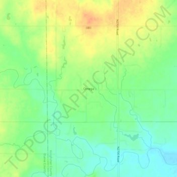
Nom : Carte topographique Omega, altitude, relief.
Lieu : Omega, Kingfisher County, Oklahoma, 73764, United States (35.85032 -98.21784 35.89032 -98.17784)
Altitude moyenne : 367 m
Altitude minimum : 349 m
Altitude maximum : 386 m
Autres cartes topographiques
Cliquez sur une carte pour visualiser sa topographie, son altitude et son relief.
Kingfisher
United States > Oklahoma > Kingfisher County
Kingfisher, Kingfisher County, Oklahoma, 73750, United States
Altitude moyenne : 329 m
Dover
United States > Oklahoma > Kingfisher County
Dover, Kingfisher County, Oklahoma, 73734, United States
Altitude moyenne : 322 m
Okarche
United States > Oklahoma > Kingfisher County
Okarche, Kingfisher County, Oklahoma, United States
Altitude moyenne : 374 m
Cashion
United States > Oklahoma > Kingfisher County
Cashion, Kingfisher County, Oklahoma, 73016, United States
Altitude moyenne : 339 m
Loyal
United States > Oklahoma > Kingfisher County
Loyal, Kingfisher County, Oklahoma, United States
Altitude moyenne : 344 m