
Carte topographique Newport
Carte interactive
Cliquez sur la carte pour afficher l’altitude.
À propos de cette carte
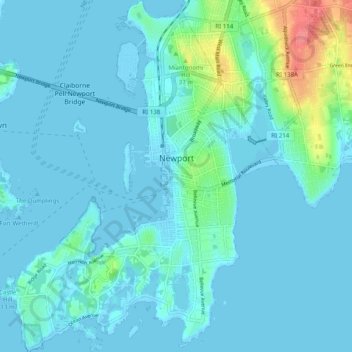
Nom : Carte topographique Newport, altitude, relief.
Lieu : Newport, Newport County, Rhode Island, 02840, United States (41.44897 -71.36345 41.52314 -71.28509)
Altitude moyenne : 8 m
Altitude minimum : -3 m
Altitude maximum : 64 m
Autres cartes topographiques
Cliquez sur une carte pour visualiser sa topographie, son altitude et son relief.
Portsmouth
United States > Rhode Island > Newport County
Portsmouth, Newport County, Rhode Island, United States
Altitude moyenne : 19 m
Fort Wetherill
United States > Rhode Island > Newport County > Jamestown
Fort Wetherill, Highland Drive, Jamestown, Newport County, Rhode Island, 02835, United States
Altitude moyenne : 4 m
Aquidneck Island
United States > Rhode Island > Newport County > Portsmouth
Aquidneck Island, Portsmouth, Newport County, Rhode Island, United States
Altitude moyenne : 13 m
Pocasset Hill
United States > Rhode Island > Newport County > Tiverton
Pocasset Hill, Tiverton, Newport County, Rhode Island, 02878, United States
Altitude moyenne : 51 m
Jamestown
United States > Rhode Island > Newport County
Jamestown, Newport County, Rhode Island, 02835, United States
Altitude moyenne : 8 m
Middletown
United States > Rhode Island > Newport County
Middletown, Newport County, Rhode Island, 02842, United States
Altitude moyenne : 19 m
Tiverton
United States > Rhode Island > Newport County
Tiverton, Newport County, Rhode Island, 02878, United States
Altitude moyenne : 31 m