
Carte topographique Kloten
Carte interactive
Cliquez sur la carte pour afficher l’altitude.
À propos de cette carte
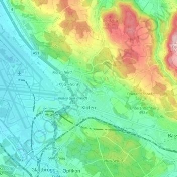
Nom : Carte topographique Kloten, altitude, relief.
Lieu : Kloten, Bezirk Bülach, Zurich, 8302, Switzerland (47.43581 8.54520 47.48131 8.62879)
Altitude moyenne : 478 m
Altitude minimum : 415 m
Altitude maximum : 618 m
Kloten has an oceanic climate (Köppen Cfb), with sizeable continental influences due to its relative elevation and distance to any large bodies of water. Precipitation is high year-round and as a result of the cold winter nights, snowfall is frequent in winter. Due to the mild afternoons, this snow seldom sticks around for long periods of time. Summers are warm with frequent convective rainfall. The skies are generally gloomy, with a slight reversal of the trend during summer.
Autres cartes topographiques
Cliquez sur une carte pour visualiser sa topographie, son altitude et son relief.
Wallisellen
Switzerland > Zurich > Bezirk Bülach
Wallisellen, Bezirk Bülach, Zurich, Switzerland
Altitude moyenne : 451 m
Glattfelden
Switzerland > Zurich > Bezirk Bülach
Glattfelden, Bezirk Bülach, Zurich, 8192, Switzerland
Altitude moyenne : 413 m
Rorbas
Switzerland > Zurich > Bezirk Bülach > Rorbas
Rorbas, Bezirk Bülach, Zurich, 8427, Switzerland
Altitude moyenne : 471 m
Nussbaumen
Switzerland > Zurich > Bezirk Bülach > Bülach > Nussbaumen
Nussbaumen, Bülach, Bezirk Bülach, Zurich, 8180, Switzerland
Altitude moyenne : 453 m
Glattbrugg
Switzerland > Zurich > Bezirk Bülach
Glattbrugg, Opfikon, Bezirk Bülach, Zurich, 8152, Switzerland
Altitude moyenne : 459 m