
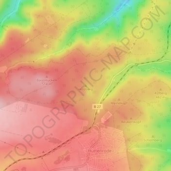
Carte topographique Holzberg
Carte interactive
Cliquez sur la carte pour afficher l’altitude.
À propos de cette carte
Nom : Carte topographique Holzberg, altitude, relief.
Altitude moyenne : 444 m
Altitude minimum : 313 m
Altitude maximum : 510 m
Autres cartes topographiques
Cliquez sur une carte pour visualiser sa topographie, son altitude et son relief.
Wienrode
Deutschland > Sachsen-Anhalt > Blankenburg
Wienrode, Blankenburg, Landkreis Harz, Sachsen-Anhalt, Deutschland
Altitude moyenne : 316 m
Derenburg
Deutschland > Sachsen-Anhalt > Blankenburg > Blankenburg
Derenburg, Blankenburg, Landkreis Harz, Sachsen-Anhalt, 38895, Deutschland
Altitude moyenne : 173 m