
Carte topographique Lakeway
Cliquez sur la carte pour afficher l’altitude.
À propos de cette carte
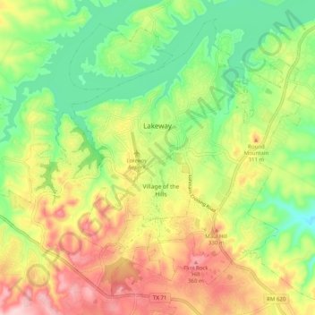
Nom : Carte topographique Lakeway, altitude, relief.
Lieu : Lakeway, Travis County, Texas, United States (30.31788 -98.04194 30.39365 -97.94229)
Altitude moyenne : 262 m
Altitude minimum : 165 m
Altitude maximum : 385 m
Autres cartes topographiques
Cliquez sur une carte pour visualiser sa topographie, son altitude et son relief.
Roy G. Guerrero Colorado River Metro Park
United States > Texas > Travis County > Austin
Altitude moyenne : 141 m
Austin
United States > Texas > Travis County > Austin
The elevation of Austin varies from 425 feet (130 m) to approximately 1,000 feet (305 m) above sea level. Due to the fact it straddles the Balcones Fault, much of the eastern part of the city is flat, with heavy clay and loam soils, whereas the western part and western suburbs consist of rolling hills on the…
Altitude moyenne : 203 m
Pflugerville
United States > Texas > Travis County > Pflugerville > Pflugerville
Altitude moyenne : 219 m