
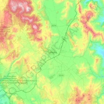
Carte topographique Tripoli
Carte interactive
Cliquez sur la carte pour afficher l’altitude.
À propos de cette carte
Nom : Carte topographique Tripoli, altitude, relief.
Altitude moyenne : 873 m
Altitude minimum : 274 m
Altitude maximum : 1’966 m
Autres cartes topographiques
Cliquez sur une carte pour visualiser sa topographie, son altitude et son relief.
Tyros
Griechenland > Peloponnes, Westgriechenland und Ionische Inseln > Regionalbezirk Arkadien > Δημοτική Ενότητα Τυρού
Tyros, Δημοτική Ενότητα Τυρού, Δήμος Νότιας Κυνουρίας, Regionalbezirk Arkadien, Region Peloponnes, Peloponnes, Westgriechenland und Ionische Inseln, 220 29, Griechenland
Altitude moyenne : 398 m
Δημοτική Ενότητα Μαντινείας
Griechenland > Peloponnes, Westgriechenland und Ionische Inseln > Regionalbezirk Arkadien
Δημοτική Ενότητα Μαντινείας, Δήμος Τρίπολης, Regionalbezirk Arkadien, Region Peloponnes, Peloponnes, Westgriechenland und Ionische Inseln, 220 05, Griechenland
Altitude moyenne : 898 m