
Carte topographique Indiana Dunes National Park
Carte interactive
Cliquez sur la carte pour afficher l’altitude.
Indiana Dunes National Park
Miller Woods is located in Miller Beach, Indiana. It is accessed through the Paul H. Douglas Center for Environmental Education on Lake Street. The area is dominated by ridge and swale topography. the ridges or swells are beach and dune sand. They date from the post Glacial Lake Nipissing period some 3000 years before present. The swales are the depressions between the ridges. They are generally either ponds or marshes.
À propos de cette carte
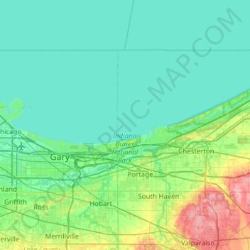
Nom : Carte topographique Indiana Dunes National Park, altitude, relief.
Altitude moyenne : 188 m
Altitude minimum : 172 m
Altitude maximum : 267 m