
Carte topographique Pamplona
Carte interactive
Cliquez sur la carte pour afficher l’altitude.
À propos de cette carte
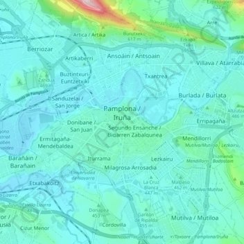
Nom : Carte topographique Pamplona, altitude, relief.
Lieu : Pamplona, Iruñerria / Comarca de Pamplona, Spain (42.78874 -1.69538 42.84244 -1.60449)
Altitude moyenne : 449 m
Altitude minimum : 402 m
Altitude maximum : 786 m
The climate of Pamplona is classified as an oceanic climate (Köppen climate classification: Cfb) with influences of a semicontinental Mediterranean climate. Due to global warming and stronger summer heat waves in the 21st century, it is also on the boundary with a humid subtropical climate. Precipitation patterns do not vary much over the course of the year, as is typical of marine climates, but both classifications are possible due to the Mediterranean patterns of somewhat drier summer months. Sunshine hours are typical for a location in Northern Spain, thus more similar to the oceanic coastal climate in nearby Basque locations than typical Spanish Mediterranean areas are, but rainfall is significantly lower than in Bilbao and especially San Sebastián, as well as the climate is harsher than in the northern coastal areas (colder winter lows, warmer summer highs) because of the altitude of 450 metres (1,480 ft) and its inland location.
Autres cartes topographiques
Cliquez sur une carte pour visualiser sa topographie, son altitude et son relief.
Oiartzabal
Spain > Iruñerria / Comarca de Pamplona > Anue
Oiartzabal, Anue, Iruñerria / Comarca de Pamplona, Spain
Altitude moyenne : 835 m
Ansoáin / Antsoain
Spain > Iruñerria / Comarca de Pamplona
Ansoáin / Antsoain, Ansoáin/Antsoain, Iruñerria / Comarca de Pamplona, Spain
Altitude moyenne : 487 m