
Carte topographique Abstäberhof
Carte interactive
Cliquez sur la carte pour afficher l’altitude.
À propos de cette carte
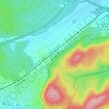
Nom : Carte topographique Abstäberhof, altitude, relief.
Altitude moyenne : 278 m
Altitude minimum : 228 m
Altitude maximum : 386 m
Autres cartes topographiques
Cliquez sur une carte pour visualiser sa topographie, son altitude et son relief.
Bayerisch Kohlhof
Deutschland > Saarland > Kirkel > Bayerisch Kohlhof
Bayerisch Kohlhof, Limbach, Kirkel, Saarpfalz-Kreis, Saarland, 66459, Deutschland
Altitude moyenne : 256 m