
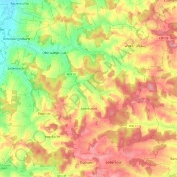
Carte topographique Attenhofen
Carte interactive
Cliquez sur la carte pour afficher l’altitude.
À propos de cette carte
Nom : Carte topographique Attenhofen, altitude, relief.
Altitude moyenne : 463 m
Altitude minimum : 399 m
Altitude maximum : 512 m
Autres cartes topographiques
Cliquez sur une carte pour visualiser sa topographie, son altitude et son relief.
Marching
Deutschland > Bayern > Landkreis Kelheim > Neustadt an der Donau
Marching, Neustadt an der Donau, Landkreis Kelheim, Bayern, 85104, Deutschland
Altitude moyenne : 364 m
Burg Prunn
Deutschland > Bayern > Landkreis Kelheim > Einthal > Nußhausen
Burg Prunn, St 2230, Nußhausen, Einthal, Riedenburg, Landkreis Kelheim, Bayern, 93339, Deutschland
Altitude moyenne : 456 m
84091
Deutschland > Bayern > Landkreis Kelheim > Attenhofen > Untereinöd
84091, Untereinöd, Attenhofen, Mainburg (VGem), Landkreis Kelheim, Bayern, Deutschland
Altitude moyenne : 463 m
Herrenau
Deutschland > Bayern > Landkreis Kelheim > Thalham
Herrenau, Thalham, Volkenschwand, Mainburg (VGem), Landkreis Kelheim, Bayern, 84106, Deutschland
Altitude moyenne : 484 m
93309
Deutschland > Bayern > Landkreis Kelheim > Kelheim
93309, Kelheim, Landkreis Kelheim, Bayern, Deutschland
Altitude moyenne : 405 m
Bad Gögging
Deutschland > Bayern > Landkreis Kelheim > Neustadt an der Donau
Bad Gögging, Neustadt an der Donau, Landkreis Kelheim, Bayern, 93333, Deutschland
Altitude moyenne : 357 m
Heiligenstadt
Deutschland > Bayern > Landkreis Kelheim > Neustadt an der Donau
Heiligenstadt, Neustadt an der Donau, Landkreis Kelheim, Bayern, 93333, Deutschland
Altitude moyenne : 360 m
Kelheim
Deutschland > Bayern > Landkreis Kelheim
Kelheim, Landkreis Kelheim, Bayern, 93309, Deutschland
Altitude moyenne : 423 m
Großberghofen
Deutschland > Bayern > Landkreis Kelheim > Kelheim
Großberghofen, Kelheim, Landkreis Kelheim, Bayern, 93309, Deutschland
Altitude moyenne : 398 m
Mühlhausen
Deutschland > Bayern > Landkreis Kelheim > Neustadt an der Donau
Mühlhausen, Neustadt an der Donau, Landkreis Kelheim, Bayern, 93333, Deutschland
Altitude moyenne : 388 m
Prunn
Deutschland > Bayern > Landkreis Kelheim
Prunn, Riedenburg, Landkreis Kelheim, Bayern, 93339, Deutschland
Altitude moyenne : 463 m
Dürnbucher Forst
Deutschland > Bayern > Landkreis Kelheim
Dürnbucher Forst, Landkreis Kelheim, Bayern, Deutschland
Altitude moyenne : 394 m
Kotiger Berg
Deutschland > Bayern > Landkreis Kelheim > Aiglsbach
Kotiger Berg, Aiglsbach, Mainburg (VGem), Landkreis Kelheim, Bayern, 84089, Deutschland
Altitude moyenne : 434 m
Weltenburg
Deutschland > Bayern > Landkreis Kelheim > Kelheim
Weltenburg, Kelheim, Landkreis Kelheim, Bayern, Deutschland
Altitude moyenne : 411 m
Wöhr
Deutschland > Bayern > Landkreis Kelheim > Neustadt an der Donau
Wöhr, Neustadt an der Donau, Landkreis Kelheim, Bayern, 93333, Deutschland
Altitude moyenne : 355 m
Gschwellhof
Deutschland > Bayern > Landkreis Kelheim > Mainburg
Gschwellhof, Mainburg, Landkreis Kelheim, Bayern, 84048, Deutschland
Altitude moyenne : 449 m
Hochstetten
Deutschland > Bayern > Landkreis Kelheim > Bad Abbach
Hochstetten, Bad Abbach, Landkreis Kelheim, Bayern, 93077, Deutschland
Altitude moyenne : 392 m
Wäscherhartl
Deutschland > Bayern > Landkreis Kelheim > Sausthal
Wäscherhartl, Sausthal, Ihrlerstein, Ihrlerstein (VGem), Landkreis Kelheim, Bayern, 93343, Deutschland
Altitude moyenne : 489 m
Abensberg
Deutschland > Bayern > Landkreis Kelheim
Abensberg, Landkreis Kelheim, Bayern, 93326, Deutschland
Altitude moyenne : 386 m
Bad Abbach
Deutschland > Bayern > Landkreis Kelheim
Bad Abbach, Landkreis Kelheim, Bayern, 93077, Deutschland
Altitude moyenne : 396 m
Saal an der Donau
Deutschland > Bayern > Landkreis Kelheim > Saal a.d.Donau
Saal an der Donau, Saal a.d.Donau, Saal an der Donau (VGem), Landkreis Kelheim, Bayern, 93342, Deutschland
Altitude moyenne : 376 m
Mainburg
Deutschland > Bayern > Landkreis Kelheim
Mainburg, Landkreis Kelheim, Bayern, 84048, Deutschland
Altitude moyenne : 456 m
Teugn
Deutschland > Bayern > Landkreis Kelheim
Teugn, Saal an der Donau (VGem), Landkreis Kelheim, Bayern, 93356, Deutschland
Altitude moyenne : 403 m
Thalham
Deutschland > Bayern > Landkreis Kelheim
Thalham, Volkenschwand, Mainburg (VGem), Landkreis Kelheim, Bayern, 84106, Deutschland
Altitude moyenne : 481 m
Oberempfenbach
Deutschland > Bayern > Landkreis Kelheim > Mainburg
Oberempfenbach, Mainburg, Landkreis Kelheim, Bayern, Deutschland
Altitude moyenne : 472 m
Peising
Deutschland > Bayern > Landkreis Kelheim > Bad Abbach
Peising, Bad Abbach, Landkreis Kelheim, Bayern, 93077, Deutschland
Altitude moyenne : 387 m
Hienheim
Deutschland > Bayern > Landkreis Kelheim > Neustadt an der Donau
Hienheim, Neustadt an der Donau, Landkreis Kelheim, Bayern, 93333, Deutschland
Altitude moyenne : 377 m
Böhmhartsberg
Deutschland > Bayern > Landkreis Kelheim > Hellring
Böhmhartsberg, Hellring, Langquaid, Langquaid (VGem), Landkreis Kelheim, Bayern, 84085, Deutschland
Altitude moyenne : 403 m
Riedenburg
Deutschland > Bayern > Landkreis Kelheim
Riedenburg, Landkreis Kelheim, Bayern, 93339, Deutschland
Altitude moyenne : 474 m
Gundelshausen
Deutschland > Bayern > Landkreis Kelheim > Kelheim
Gundelshausen, Kelheim, Landkreis Kelheim, Bayern, Deutschland
Altitude moyenne : 382 m
Oberleierndorf
Deutschland > Bayern > Landkreis Kelheim
Oberleierndorf, Langquaid, Langquaid (VGem), Landkreis Kelheim, Bayern, 84085, Deutschland
Altitude moyenne : 398 m
Lohstadt
Deutschland > Bayern > Landkreis Kelheim > Kelheim > Gundelshausen > Lohstadt
Lohstadt, Gundelshausen, Kelheim, Landkreis Kelheim, Bayern, Deutschland
Altitude moyenne : 399 m
Riedenburg
Deutschland > Bayern > Landkreis Kelheim
Riedenburg, Landkreis Kelheim, Bayern, 93339, Deutschland
Altitude moyenne : 457 m
Irnsing
Deutschland > Bayern > Landkreis Kelheim > Neustadt an der Donau > Irnsing
Irnsing, Neustadt an der Donau, Landkreis Kelheim, Bayern, 93333, Deutschland
Altitude moyenne : 370 m
Poikam
Deutschland > Bayern > Landkreis Kelheim > Bad Abbach > Poikam
Poikam, Bad Abbach, Landkreis Kelheim, Bayern, 93077, Deutschland
Altitude moyenne : 371 m
Mauern
Deutschland > Bayern > Landkreis Kelheim > Neustadt an der Donau
Mauern, Neustadt an der Donau, Landkreis Kelheim, Bayern, 93333, Deutschland
Altitude moyenne : 353 m
Staubing
Deutschland > Bayern > Landkreis Kelheim > Kelheim
Staubing, Kelheim, Landkreis Kelheim, Bayern, 93343, Deutschland
Altitude moyenne : 395 m
Willersdorf
Deutschland > Bayern > Landkreis Kelheim > Willersdorf
Willersdorf, Wildenberg, Siegenburg (VGem), Landkreis Kelheim, Bayern, 93359, Deutschland
Altitude moyenne : 452 m
Meilenhofen
Deutschland > Bayern > Landkreis Kelheim > Mainburg > Meilenhofen
Meilenhofen, Mainburg, Landkreis Kelheim, Bayern, 84048, Deutschland
Altitude moyenne : 431 m
Adlhausen
Deutschland > Bayern > Landkreis Kelheim > Adlhausen
Adlhausen, Langquaid, Langquaid (VGem), Landkreis Kelheim, Bayern, 84085, Deutschland
Altitude moyenne : 420 m
Eining
Deutschland > Bayern > Landkreis Kelheim > Neustadt an der Donau
Eining, Neustadt an der Donau, Landkreis Kelheim, Bayern, 93333, Deutschland
Altitude moyenne : 372 m
Siegenburg
Deutschland > Bayern > Landkreis Kelheim
Siegenburg, Siegenburg (VGem), Landkreis Kelheim, Bayern, 93354, Deutschland
Altitude moyenne : 419 m
Sandharlanden
Deutschland > Bayern > Landkreis Kelheim
Sandharlanden, Abensberg, Landkreis Kelheim, Bayern, 93326, Deutschland
Altitude moyenne : 381 m
Kleinberghofen
Deutschland > Bayern > Landkreis Kelheim > Saal a.d.Donau > Kleinberghofen
Kleinberghofen, Saal a.d.Donau, Saal an der Donau (VGem), Landkreis Kelheim, Bayern, 93345, Deutschland
Altitude moyenne : 392 m
Biburg
Deutschland > Bayern > Landkreis Kelheim
Biburg, Siegenburg (VGem), Landkreis Kelheim, Bayern, Deutschland
Altitude moyenne : 387 m
Ihrlerstein
Deutschland > Bayern > Landkreis Kelheim
Ihrlerstein, Ihrlerstein (VGem), Landkreis Kelheim, Bayern, 93346, Deutschland
Altitude moyenne : 473 m
Essing
Deutschland > Bayern > Landkreis Kelheim
Essing, Ihrlerstein (VGem), Landkreis Kelheim, Bayern, 93343, Deutschland
Altitude moyenne : 465 m
Hienheimer Forst
Deutschland > Bayern > Landkreis Kelheim > Kelheim
Hienheimer Forst, Kelheim, Landkreis Kelheim, Bayern, Deutschland
Altitude moyenne : 426 m