
Carte topographique The Botanic Garden at Oklahoma State University
Carte interactive
Cliquez sur la carte pour afficher l’altitude.
À propos de cette carte
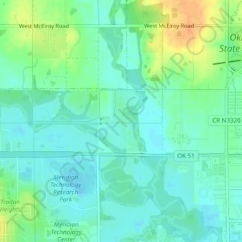
Nom : Carte topographique The Botanic Garden at Oklahoma State University, altitude, relief.
Altitude moyenne : 275 m
Altitude minimum : 264 m
Altitude maximum : 297 m
Autres cartes topographiques
Cliquez sur une carte pour visualiser sa topographie, son altitude et son relief.
Stillwater
United States > Oklahoma > Payne County > Stillwater
Stillwater, Payne County, Oklahoma, 74077, United States
Altitude moyenne : 295 m