
Carte topographique Dell Rapids Township
Carte interactive
Cliquez sur la carte pour afficher l’altitude.
À propos de cette carte
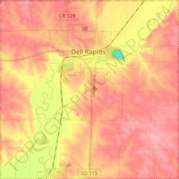
Nom : Carte topographique Dell Rapids Township, altitude, relief.
Altitude moyenne : 470 m
Altitude minimum : 400 m
Altitude maximum : 502 m
Autres cartes topographiques
Cliquez sur une carte pour visualiser sa topographie, son altitude et son relief.
Sioux Falls
United States > South Dakota > Minnehaha County
Sioux Falls, Sioux Falls Township, Minnehaha County, South Dakota, United States
Altitude moyenne : 445 m
Brandon
United States > South Dakota > Minnehaha County
Brandon, Brandon Township, Minnehaha County, South Dakota, 57005, United States
Altitude moyenne : 415 m
Brandon Township
United States > South Dakota > Minnehaha County
Brandon Township, Minnehaha County, South Dakota, United States
Altitude moyenne : 428 m
Edison Township
United States > South Dakota > Minnehaha County
Edison Township, Minnehaha County, South Dakota, United States
Altitude moyenne : 459 m
Colton
United States > South Dakota > Minnehaha County
Colton, Taopi Township, Minnehaha County, South Dakota, United States
Altitude moyenne : 491 m
Baltic
United States > South Dakota > Minnehaha County
Baltic, Sverdup Township, Minnehaha County, South Dakota, United States
Altitude moyenne : 454 m
Dell Rapids
United States > South Dakota > Minnehaha County > Dell Rapids
Dell Rapids, Minnehaha County, South Dakota, 50722, United States
Altitude moyenne : 462 m