
Carte topographique Pahrump
Carte interactive
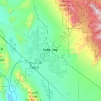
Cliquez sur la carte pour afficher l’altitude.
À propos de cette carte
Nom : Carte topographique Pahrump, altitude, relief.
Lieu : Pahrump, Nye County, Nevada, United States (36.00121 -116.22802 36.40983 -115.89443)
Altitude moyenne : 1’141 m
Altitude minimum : 641 m
Altitude maximum : 3’143 m
Summers in Pahrump are generally very hot and dry, with occasional pushes of monsoonal moisture beginning in early July. Being at a similar elevation to Las Vegas, daytime highs in summer average within a few degrees lower than that of Las Vegas. Record highs are similar between the two cities as well. A typical day during June through August brings temperatures around 100 °F (38 °C), and occasionally 110 °F (43 °C). Nighttime temperatures, however, are noticeably cooler. This is due to the lack of an urban heat island in Pahrump, allowing for intense radiative cooling after sundown. As a result, summer nights are pleasantly warm, bottoming out in the mid-60s or 70s °F (around 20 °C). Pahrump's location in a valley leads to large diurnal temperature ranges, typically 30 °F (17 °C) but occasionally 40 °F (22 °C). By late August and early September, the sweltering summer heat noticeably tempers down. September is the gateway to fall, which brings very pleasant weather. October highs are generally 80 °F (27 °C) and nighttime temperatures in the 50s °F (low teens °C). Due to its elevation, Pahrump is protected from the searing summer temperatures experienced in the nearby Death Valley.
Autres cartes topographiques
Cliquez sur une carte pour visualiser sa topographie, son altitude et son relief.
Tonopah
United States > Nevada > Nye County
Tonopah, Nye County, Nevada, United States
Altitude moyenne : 1’842 m