
Carte topographique Johns Creek
Carte interactive
Cliquez sur la carte pour afficher l’altitude.
À propos de cette carte
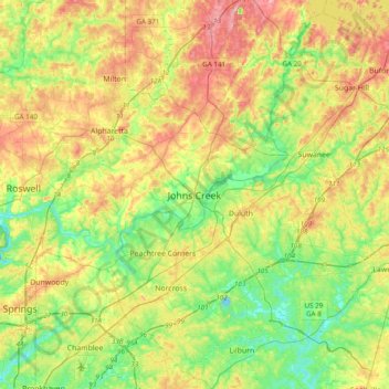
Nom : Carte topographique Johns Creek, altitude, relief.
Lieu : Johns Creek, Fulton County, Georgia, 30097, United States (33.85816 -84.35020 34.17816 -84.03020)
Altitude moyenne : 314 m
Altitude minimum : 253 m
Altitude maximum : 402 m
Johns Creek is located in northeastern Fulton County and is centered at 34°1′44″N 84°11′55″W / 34.02889°N 84.19861°W / 34.02889; -84.19861 (34.0289259, -84.1985790). The elevation ranges from 880 feet (270 m) above sea level along the Chattahoochee River to 1,180 feet (360 m) in the Ocee area along the Alpharetta border. Johns Creek is bounded to the south by the Chattahoochee River and Gwinnett County, and on the northeast by McGinnis Ferry Road and Forsyth County. It is bounded by Roswell to the west, Alpharetta to the northwest, Suwanee to the east, and Duluth, Berkeley Lake, and Peachtree Corners to the south. Downtown Atlanta is 27 miles (43 km) to the southwest.
Autres cartes topographiques
Cliquez sur une carte pour visualiser sa topographie, son altitude et son relief.
Shake Rag
United States > Georgia > Fulton County > Johns Creek
Shake Rag, Johns Creek, Fulton County, Georgia, 30095, United States
Altitude moyenne : 300 m
Johns Creek
United States > Georgia > Fulton County > Johns Creek > Johns Creek
Johns Creek, Fulton County, Georgia, 30097, United States
Altitude moyenne : 305 m