
Carte topographique Rindge
Carte interactive
Cliquez sur la carte pour afficher l’altitude.
À propos de cette carte
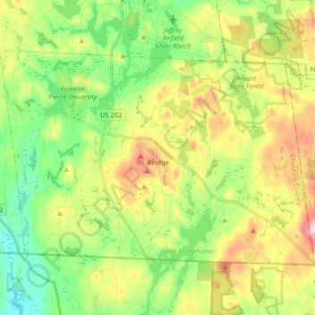
Nom : Carte topographique Rindge, altitude, relief.
Lieu : Rindge, Cheshire County, New Hampshire, United States (42.71216 -72.09126 42.79331 -71.92886)
Altitude moyenne : 343 m
Altitude minimum : 256 m
Altitude maximum : 481 m
According to the United States Census Bureau, the town has a total area of 39.8 square miles (103.1 km2), of which 37.1 square miles (96.1 km2) are land and 2.7 square miles (7.0 km2) are water, comprising 6.76% of the town. Rindge is located in a hilly upland lake region. Hubbard Pond is in the northeast, Contoocook Lake on the northern boundary, Pearly Lake is in the northwest, and Lake Monomonac is on the southern boundary. The town is located on a regional watershed divide and is the headwaters for two river systems. The Contoocook River flows north to the Merrimack River, thence to the Gulf of Maine, and the North Branch of the Millers River flows southwest to the Connecticut River, thence to Long Island Sound. Rindge's highest point is on its eastern border, on the lower slopes of Pratt Mountain, where the elevation reaches 1,505 feet (459 m) above sea level.
Autres cartes topographiques
Cliquez sur une carte pour visualiser sa topographie, son altitude et son relief.
Stoddard
United States > New Hampshire > Cheshire County
Stoddard, Cheshire County, New Hampshire, United States
Altitude moyenne : 451 m
Chesterfield
United States > New Hampshire > Cheshire County
Chesterfield, Cheshire County, New Hampshire, United States
Altitude moyenne : 229 m
Harrisville
United States > New Hampshire > Cheshire County
Harrisville, Cheshire County, New Hampshire, 03450, United States
Altitude moyenne : 422 m
Gilboa Mountain
United States > New Hampshire > Cheshire County > Westmoreland
Gilboa Mountain, Westmoreland, Cheshire County, New Hampshire, 03467, United States
Altitude moyenne : 331 m
Westmoreland
United States > New Hampshire > Cheshire County
Westmoreland, Cheshire County, New Hampshire, 03467, United States
Altitude moyenne : 228 m
Alstead
United States > New Hampshire > Cheshire County
Alstead, Cheshire County, New Hampshire, United States
Altitude moyenne : 289 m
West Chesterfield
United States > New Hampshire > Cheshire County > Chesterfield
West Chesterfield, Chesterfield, Cheshire County, New Hampshire, 03466, United States
Altitude moyenne : 168 m
Marlborough
United States > New Hampshire > Cheshire County
Marlborough, Cheshire County, New Hampshire, 03455, United States
Altitude moyenne : 299 m
Winchester
United States > New Hampshire > Cheshire County > Winchester
Winchester, Cheshire County, New Hampshire, United States
Altitude moyenne : 167 m
Pisgah State Park
United States > New Hampshire > Cheshire County > Winchester
Pisgah State Park, Winchester, Cheshire County, New Hampshire, United States
Altitude moyenne : 250 m
Keene
United States > New Hampshire > Cheshire County
Keene, Cheshire County, New Hampshire, United States
Altitude moyenne : 263 m
Harper Acres
United States > New Hampshire > Cheshire County > Keene
Harper Acres, Keene, Cheshire County, New Hampshire, 03431, United States
Altitude moyenne : 156 m
Fitzwilliam
United States > New Hampshire > Cheshire County
Fitzwilliam, Cheshire County, New Hampshire, 03447, United States
Altitude moyenne : 345 m
Jaffrey
United States > New Hampshire > Cheshire County
Jaffrey, Cheshire County, New Hampshire, 03452, United States
Altitude moyenne : 351 m
Monte Rosa
United States > New Hampshire > Cheshire County > Jaffrey
Monte Rosa, Jaffrey, Cheshire County, New Hampshire, United States
Altitude moyenne : 634 m