
Carte topographique Chamarel
Carte interactive
Cliquez sur la carte pour afficher l’altitude.
À propos de cette carte
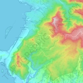
Nom : Carte topographique Chamarel, altitude, relief.
Lieu : Chamarel, Black River, Outer islands of Mauritius, Mauritius (-20.45683 57.35908 -20.40879 57.47367)
Altitude moyenne : 225 m
Altitude minimum : 0 m
Altitude maximum : 815 m
Chamarel is a village located in the western hills on the west coast of Mauritius at an elevation of about 850 feet (260 m) between Savanne and the Black river districts where the cascades are formed on the River du Capano flowing through an "amphitheater of abrupt rocks". It is a wooded plateau. The village is known for its "hushed bucolic vibe and cool breezes". It is 6 kilometres (3.7 mi) from the coast. Fauna noted in the forest surrounding the town is tortoise.
Autres cartes topographiques
Cliquez sur une carte pour visualiser sa topographie, son altitude et son relief.
Trois Mamelles mountain
Mauritius > Black River > Cascavelle
Trois Mamelles mountain, Cascavelle, Black River, 73324, Mauritius
Altitude moyenne : 288 m
Canot
Mauritius > Black River > Canot
Canot, Gros Cailloux, Black River, Outer islands of Mauritius, 71406, Mauritius
Altitude moyenne : 119 m
Flic en Flac
Mauritius > Black River > Flic en Flac
Flic en Flac, Black River, 90512, Mauritius
Altitude moyenne : 22 m
La Gaulette
Mauritius > Black River > La Gaulette
La Gaulette, Black River, Mauritius
Altitude moyenne : 94 m