
Carte topographique Rohini Tehsil
Carte interactive
Cliquez sur la carte pour afficher l’altitude.
À propos de cette carte
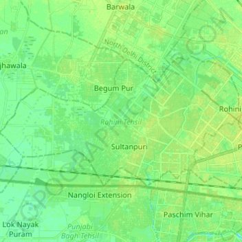
Nom : Carte topographique Rohini Tehsil, altitude, relief.
Lieu : Rohini Tehsil, North West Delhi, Delhi, India (28.68223 77.00119 28.73962 77.12274)
Altitude moyenne : 216 m
Altitude minimum : 209 m
Altitude maximum : 221 m
Autres cartes topographiques
Cliquez sur une carte pour visualiser sa topographie, son altitude et son relief.
Rohini
India > Delhi > Rohini Tehsil
Rohini, Rohini Tehsil, North West Delhi District, Delhi, India
Altitude moyenne : 215 m