
Carte topographique Bernau
Carte interactive
Cliquez sur la carte pour afficher l’altitude.
À propos de cette carte
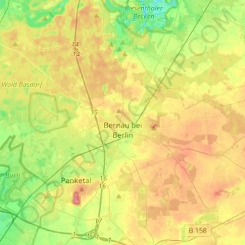
Nom : Carte topographique Bernau, altitude, relief.
Lieu : Bernau, Barnim, Brandenburg, 16321, Germany (52.60855 13.46712 52.75710 13.66846)
Altitude moyenne : 72 m
Altitude minimum : 35 m
Altitude maximum : 115 m
Autres cartes topographiques
Cliquez sur une carte pour visualiser sa topographie, son altitude et son relief.
Stolzenhagen
Germany > Brandenburg > Barnim > Lunow-Stolzenhagen
Stolzenhagen, Lunow-Stolzenhagen, Britz-Chorin-Oderberg, Barnim, Brandenburg, 16248, Germany
Altitude moyenne : 28 m
Eberswalde
Germany > Brandenburg > Barnim
Eberswalde, Barnim, Brandenburg, Germany
Altitude moyenne : 53 m