
Carte topographique Vienna
Carte interactive
Cliquez sur la carte pour afficher l’altitude.
Vienna
Vienna is located at 38°54′N 77°16′W / 38.900°N 77.267°W / 38.900; -77.267 (38.8991, −77.2607), at an elevation of 358 feet (109 meters). It lies in the Piedmont approximately 5.5 miles (8.9 km) southwest of the Potomac River. Wolftrap Creek, a tributary of nearby Difficult Run, flows north from its source in the eastern part of town. The Bear Branch of Accotink Creek, a Potomac tributary, flows south from its source in the southern part of town. Located in Northern Virginia on Interstate 66, Vienna is 12 miles (19 km) west of Washington, D.C. and 2 miles (3.2 km) northeast of Fairfax, the county seat.
À propos de cette carte
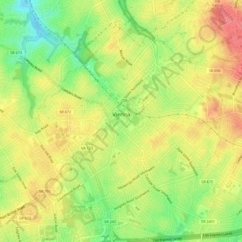
Nom : Carte topographique Vienna, altitude, relief.
Lieu : Vienna, Fairfax County, Virginia, United States (38.87854 -77.28476 38.92182 -77.24109)
Altitude moyenne : 117 m
Altitude minimum : 76 m
Altitude maximum : 151 m
Autres cartes topographiques
Cliquez sur une carte pour visualiser sa topographie, son altitude et son relief.
Izaak Walton League of America - Arlington-Fairfax Chapter
United States > Virginia > Fairfax County > Centreville
Altitude moyenne : 72 m
George Washington's Mount Vernon
United States > Virginia > Fairfax County > Mount Vernon
Visitors to Mount Vernon now see Washington's study, a room to which in the 18th century only a privileged few were granted entry. This simply furnished room has a combined bathroom, dressing room and office; the room was so private that few contemporary descriptions exist. Its walls are lined with naturally…
Altitude moyenne : 14 m
Mount Vernon Community Park
United States > Virginia > Fairfax County > Fort Hunt > Snowden
Altitude moyenne : 14 m
Shirley Gate Park
United States > Virginia > Fairfax County > George Mason > Shirley Gate Park
Altitude moyenne : 128 m