
Carte topographique Montezuma County
Carte interactive
Cliquez sur la carte pour afficher l’altitude.
À propos de cette carte
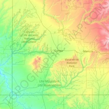
Nom : Carte topographique Montezuma County, altitude, relief.
Lieu : Montezuma County, Colorado, United States of America (36.99897 -109.04593 37.63775 -107.96859)
Altitude moyenne : 2’025 m
Altitude minimum : 1’370 m
Altitude maximum : 3’978 m
A large county, roughly 1/3 of its area is tribal land, 1/3 is federal land (administered by the National Park Service, the United States Forest Service and the Bureau of Land Management), and 1/3 private or state/county land. It is also varied topographically, ranging in elevation from about 6,000 feet (1,800 m) to more than 13,200 feet (4,000 m), and from high Colorado Plateau desert to alpine tundra. The county has the second largest reservoir in Colorado, McPhee Reservoir, many other large reservoirs, and hundreds of private lakes and ponds. Much of the county is irrigated cropland, and it produces fruit, large numbers of cattle and sheep, and beans. It is served by U.S. Highways 160 and 491 (formerly US 666), and by Cortez Municipal Airport. It has no rail service, although both Mancos and Dolores were established as railroad towns in the 1890s.
Autres cartes topographiques
Cliquez sur une carte pour visualiser sa topographie, son altitude et son relief.
Hinsdale County
United States of America > Colorado
Hinsdale County, Colorado, 81235, United States of America
Altitude moyenne : 3’312 m
Otero County
United States of America > Colorado
Otero County, Colorado, United States of America
Altitude moyenne : 1’357 m
Routt County
United States of America > Colorado
Routt County, Colorado, United States of America
Altitude moyenne : 2’537 m
Mineral County
United States of America > Colorado
Mineral County, Colorado, United States of America
Altitude moyenne : 3’202 m
Saguache County
United States of America > Colorado
Saguache County, Colorado, United States of America
Altitude moyenne : 2’819 m
Las Animas County
United States of America > Colorado
Las Animas County, Colorado, United States of America
Altitude moyenne : 1’771 m
Garfield County
United States of America > Colorado
Garfield County, Colorado, United States of America
Altitude moyenne : 2’315 m
Clear Creek County
United States of America > Colorado
Clear Creek County, Colorado, United States of America
Altitude moyenne : 3’147 m
Pueblo County
United States of America > Colorado
Pueblo County, Colorado, United States of America
Altitude moyenne : 1’629 m
Denver County
United States of America > Colorado
Denver County, Colorado, United States of America
Altitude moyenne : 1’673 m
Larimer County
United States of America > Colorado
Larimer County, Colorado, United States of America
Altitude moyenne : 2’363 m
Boulder
United States of America > Colorado > Boulder
Boulder, Boulder County, Colorado, United States of America
Altitude moyenne : 1’786 m