
Carte topographique Mountain City
Carte interactive
Cliquez sur la carte pour afficher l’altitude.
À propos de cette carte
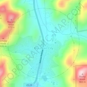
Nom : Carte topographique Mountain City, altitude, relief.
Lieu : Mountain City, Rabun County, Georgia, 30562, United States (34.90855 -83.39892 34.93057 -83.37193)
Altitude moyenne : 747 m
Altitude minimum : 635 m
Altitude maximum : 985 m
Mountain City is an incorporated town in Rabun County, Georgia, United States. The population was 904 at the 2020 census. The town straddles the Eastern Continental Divide in a deep gap in the Blue Ridge Mountain front. The gap allows U.S. Route 441 to cross the range at an elevation of 2168 feet without the significant grade required by roadways at most other mountain passes along the Georgia Blue Ridge.
Autres cartes topographiques
Cliquez sur une carte pour visualiser sa topographie, son altitude et son relief.
Chestnut Mountain
United States > Georgia > Rabun County
Chestnut Mountain, Rabun County, Georgia, 30537, United States
Altitude moyenne : 834 m
Clayton
United States > Georgia > Rabun County
Clayton, Rabun County, Georgia, 30525, United States
Altitude moyenne : 621 m
Sky Valley
United States > Georgia > Rabun County
Sky Valley, Rabun County, Georgia, 30537, United States
Altitude moyenne : 973 m
Elisha Mountain
United States > Georgia > Rabun County
Elisha Mountain, Rabun County, Georgia, 30525, United States
Altitude moyenne : 828 m
Lake Burton
United States > Georgia > Rabun County
Lake Burton, Rabun County, Georgia, United States
Altitude moyenne : 662 m
Blalock
United States > Georgia > Rabun County
Blalock, Rabun County, Georgia, United States
Altitude moyenne : 682 m
Black Rock Mountain State Park
United States > Georgia > Rabun County > Mountain City
Black Rock Mountain State Park, Mountain City, Rabun County, Georgia, United States
Altitude moyenne : 833 m
Tallulah Gorge State Park
United States > Georgia > Rabun County > Tallulah Falls
Tallulah Gorge State Park, Tallulah Falls, Rabun County, Georgia, United States
Altitude moyenne : 435 m
Tallulah Gorge
United States > Georgia > Rabun County > Tallulah Falls
Tallulah Gorge, Tallulah Falls, Rabun County, Georgia, United States
Altitude moyenne : 465 m
Lakemont
United States > Georgia > Rabun County
Lakemont, Rabun County, Georgia, 30581, United States
Altitude moyenne : 547 m
Dillard
United States > Georgia > Rabun County
Dillard, Rabun County, Georgia, United States
Altitude moyenne : 691 m
Rabun Gap Nacoochee School Lake
United States > Georgia > Rabun County
Rabun Gap Nacoochee School Lake, Rabun County, Georgia, United States
Altitude moyenne : 671 m
Ben Mountain
United States > Georgia > Rabun County
Ben Mountain, Rabun County, Georgia, 30537, United States
Altitude moyenne : 866 m
Rabun Gap Nacoochee School Lake Dam
United States > Georgia > Rabun County
Rabun Gap Nacoochee School Lake Dam, Rabun County, Georgia, 30568, United States
Altitude moyenne : 671 m
Lake Seed
United States > Georgia > Rabun County
Lake Seed, Rabun County, Georgia, United States
Altitude moyenne : 653 m