
Carte topographique Évora
Carte interactive
Cliquez sur la carte pour afficher l’altitude.
À propos de cette carte
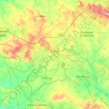
Nom : Carte topographique Évora, altitude, relief.
Lieu : Évora, Portugal (38.34068 -8.16570 38.76820 -7.55494)
Altitude moyenne : 247 m
Altitude minimum : 112 m
Altitude maximum : 550 m
Évora (altitude 300m) is situated in Alentejo, a large region of wide plains in the south of Portugal, bordered to the North by the Tagus River and to the South by the region of Algarve. The city is 140 km (87 mi) from the capital city Lisbon, and 80 km (50 mi) from Badajoz at the Spanish border. It is the chief city of the region.
Autres cartes topographiques
Cliquez sur une carte pour visualiser sa topographie, son altitude et son relief.
Juromenha
Portugal > Évora > Alandroal (Nossa Senhora da Conceição), São Brás dos Matos (Mina do Bugalho) e Juromenha (Nossa Senhora do Loreto)
Juromenha, Alandroal (Nossa Senhora da Conceição), São Brás dos Matos (Mina do Bugalho) e Juromenha (Nossa Senhora do Loreto), Alandroal, Évora, 7250-242, Portugal
Altitude moyenne : 165 m