
Carte topographique Harpers Ferry
Carte interactive
Cliquez sur la carte pour afficher l’altitude.
À propos de cette carte
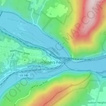
Nom : Carte topographique Harpers Ferry, altitude, relief.
Altitude moyenne : 174 m
Altitude minimum : 71 m
Altitude maximum : 421 m
The town was "easy to seize, and hard to hold", because of its topography: surrounded on three sides by high ground – Bolivar Heights to the west, Loudoun Heights to the south, and Maryland Heights to the east – and surrounded by the Potomac and Shenandoah Rivers, anyone who controlled the heights controlled the city.
Autres cartes topographiques
Cliquez sur une carte pour visualiser sa topographie, son altitude et son relief.
Shepherdstown
United States > West Virginia > Jefferson County
Shepherdstown, Jefferson County, West Virginia, 25443, United States
Altitude moyenne : 126 m
Kearneysville
United States > West Virginia > Jefferson County > Kearneysville
Kearneysville, Jefferson County, West Virginia, 25430-9047, United States
Altitude moyenne : 162 m
Harpers Ferry National Historical Park
United States > West Virginia > Jefferson County > Bolivar
Harpers Ferry National Historical Park, Bolivar, Jefferson County, West Virginia, United States
Altitude moyenne : 161 m
Charles Town
United States > West Virginia > Jefferson County
Charles Town, Jefferson County, West Virginia, United States
Altitude moyenne : 150 m
Halltown
United States > West Virginia > Jefferson County > Halltown
Halltown, Jefferson County, West Virginia, 25423, United States
Altitude moyenne : 133 m
Ranson
United States > West Virginia > Jefferson County
Ranson, Jefferson County, West Virginia, 25438, United States
Altitude moyenne : 161 m