Géolocaliser

Carte topographique Westwood

Cliquez sur la carte pour afficher l’altitude.

À propos de cette carte

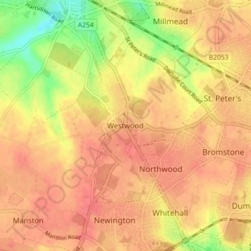
Nom : Carte topographique Westwood, altitude, relief.

Lieu : Westwood, Thanet District, Kent, England, CT10 2NU, United Kingdom (51.34117 1.37453 51.38117 1.41453)

Altitude moyenne : 40 m

Altitude minimum : 4 m

Altitude maximum : 56 m

Autres cartes topographiques

Cliquez sur une carte pour visualiser sa topographie, son altitude et son relief.

Stour

United Kingdom > England > Kent > Thanet District

The source, of what is known at that point as the Great Stour, is near the village of Lenham, within a short distance of the River Len, a tributary of the Medway. The source is at a high elevation close to the North Downs escarpment. At first the river flows south east in a narrow valley parallel to the…

Altitude moyenne : 7 m

Botany Bay

United Kingdom > England > Kent > Thanet District > Margate

Altitude moyenne : 9 m

Équipez-vous pour votre prochaine aventure :

🕶️Lunettes de soleil montagne - Protection UV en altitude
🎒Sac d'hydratation VTT - Design ergonomique pour ne pas gêner les mouvements en descente
🪖Casques vélo et VTT - Protection en terrain accidenté
🏔️Équipement de montagne - Préparation complète outdoor
🧣Tour de cou multifonction - Protège du froid, du vent ou du soleil selon vos besoins

En tant que Partenaire Amazon, ce site perçoit une commission sur les achats éligibles sans surcoût pour vous.