
Carte topographique Madill
Carte interactive
Cliquez sur la carte pour afficher l’altitude.
À propos de cette carte
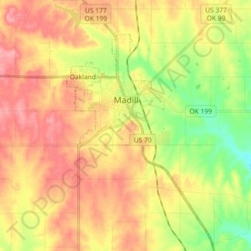
Nom : Carte topographique Madill, altitude, relief.
Lieu : Madill, Marshall County, Oklahoma, 73446, United States (34.02561 -96.79837 34.13279 -96.72625)
Altitude moyenne : 248 m
Altitude minimum : 198 m
Altitude maximum : 290 m
There is also a small municipal airport (FAA code 1F4) named Madill Municipal Airport, 3 miles (4.8 km) northwest of the city. It has one asphalt runway, 18/36, that is 3,000 feet (910 m) by 60 feet (18 m) at elevation 862 feet (263 m). The airport beacon operates between sunrise and sunset every day. There is no control tower.
Autres cartes topographiques
Cliquez sur une carte pour visualiser sa topographie, son altitude et son relief.
Lake Texoma
United States > Oklahoma > Marshall County
Lake Texoma, Marshall County, Oklahoma, United States
Altitude moyenne : 213 m
Antioch
United States > Oklahoma > Marshall County
Antioch, Marshall County, Oklahoma, United States
Altitude moyenne : 269 m
Kingston
United States > Oklahoma > Marshall County
Kingston, Marshall County, Oklahoma, United States
Altitude moyenne : 239 m
Cumberland
United States > Oklahoma > Marshall County > Cumberland
Cumberland, Marshall County, Oklahoma, United States
Altitude moyenne : 212 m