
Carte topographique Montmorency Township
Carte interactive
Cliquez sur la carte pour afficher l’altitude.
À propos de cette carte
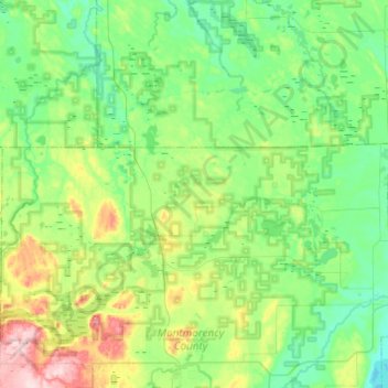
Nom : Carte topographique Montmorency Township, altitude, relief.
Altitude moyenne : 270 m
Altitude minimum : 218 m
Altitude maximum : 439 m
Autres cartes topographiques
Cliquez sur une carte pour visualiser sa topographie, son altitude et son relief.
Atlanta
United States > Michigan > Montmorency County
Atlanta, Briley Township, Montmorency County, Michigan, United States
Altitude moyenne : 275 m
Hillman Township
United States > Michigan > Montmorency County
Hillman Township, Montmorency County, Michigan, 49746, United States
Altitude moyenne : 260 m
Lewiston
United States > Michigan > Montmorency County
Lewiston, Albert Township, Montmorency County, Michigan, 49756, United States
Altitude moyenne : 380 m
Hillman
United States > Michigan > Montmorency County
Hillman, Hillman Township, Montmorency County, Michigan, United States
Altitude moyenne : 234 m